

EXPERTISE YOU CAN TRUST
At Petras Land Surveying, we offer a comprehensive range of Legal Surveys. From initial concept to the final signed plan, our team brings a wealth of experience and will handle each project with the utmost professionalism.
Subdivision applications are required when a property owner or developer wants to create two or more lots out of an existing parcel or simply wants to move the boundary line between two adjacent properties. The application process typically starts with a Site Plan showing the proposed Subdivision configuration and requires approval from the local Approving Officer.
As Subdivision Applications are often complex, we encourage prospective clients to reach out and discuss the requirements with a member of our team.

Strata Surveys range from 2-unit residential duplexes to multi-building mixed-use developments. We work with developers and builders to define the boundaries between Strata Lots, shared Common Property and Limited Common Property within a Strata Development. Petras Land Surveying offers the following services:
- Building Stata Plans
- Bare Land Strata Plans
- Proposed Strata Plans for Disclosure Statements
- Amending existing Strata Plans (to redefine how the Strata Corporation uses a specific area)
As Strata Plans are dynamic, we encourage prospective clients to reach out and discuss the site requirements with a member of our team.

Circumstances determine when a legal charge may need to be registered on title or on that of a neighboring parcel. This can range from an easement over an access driveway, a Statutory Right of Way over a utility company’s infrastructure or a Restrictive Covenant protecting sensitive environmental wetlands. Each project is unique and we work with our client to understand the scope of their project.

By their very definition, natural boundaries can move. There are times when a new survey plan showing the updated location of the present natural boundary is required for a building permit or subdivision application. Our team is experienced in determining the location of the natural boundary and can prepare application packages that are submitted to the Surveyor General when required. As these types of applications are dynamic, we encourage prospective clients to reach out and discuss their particular project with a member of our team.

When our clients need to know where their property ends and the adjacent one begins (whether retracing District Lot boundaries from an original 1890’s survey or redefining residential city lots) we research the existing records, thoroughly look for original survey evidence in the field, and then reestablish the location of the boundary lines and set new survey posts at the corners. We complete the survey plan for registration in the Land Title Office.

trustworthy land surveyor near you
Covering all of Vancouver Island


Recent Articles

Understanding the Vital Role of Land Surveyors in Property Development
When embarking on a property development project, whether in the picturesque Comox Valley or beyond, the importance of land surveyors cannot be overstated. These professionals play a crucial role in ensuring that your project proceeds smoothly, adhering to legal requirements and design specifications. The Key Responsibilities of a Land Surveyor Land surveyors, also known as…

Unraveling the Mystery of Strata Title Surveys
If you’re looking to develop properties on Vancouver Island, especially in the vibrant Comox Valley, you may come across the term “strata title surveys.” But what exactly are they, and why are they essential for your property development project? Let’s dive into the world of strata titles and the role they play. Understanding Strata Title…

The Role of Land Surveying in Subdivision Planning
Subdividing land is a common practice when it comes to property development. Whether you’re looking to create a residential community or divide a large parcel of land for various purposes, land surveying plays a pivotal role in ensuring a successful and compliant subdivision. Here’s a closer look at the importance of subdivision surveys and their…

Ensuring Property Boundary Clarity with Reference Plans
Property boundaries are the foundation of land ownership, and ensuring their accuracy and clarity is essential for avoiding disputes and legal issues. Reference plans, created by land surveyors, are a valuable tool in this regard. Let’s explore the importance of reference plans and their role in maintaining property boundary clarity in Vancouver Island and beyond.…

The Art and Science of Easements and Rights of Way
Easements and rights of way are legal instruments that grant permission to individuals or entities to access or use a portion of another person’s land for a specific purpose. These concepts play a vital role in property ownership, land development, and infrastructure planning. In this article, we explore the art and science of easements and…

A Guide to Construction Layout Surveys
In the world of construction, precision and accuracy are non-negotiable. A vital tool in ensuring that building projects are executed flawlessly is the construction layout survey. Whether you’re planning a project in the Comox Valley, North Island, or elsewhere, understanding the importance of these surveys can make a significant difference. In this guide, we explore…

Elevation Certificates: What You Need to Know
If you own property in a flood-prone area or are planning to buy one, you’ve likely come across the term “elevation certificate.” Understanding what it is and why it matters can make a significant difference in protecting your investment and ensuring your property’s compliance with local regulations. In this article, we’ll dive into elevation certificates…

Land Surveying in Property Development: A Key to Success
In the world of property development, the role of land surveying cannot be overstated. Land surveyors are the unsung heroes behind the scenes, ensuring that projects proceed with precision, compliance, and success. Whether you’re planning a development project in the Comox Valley, North Island, or other areas of Vancouver Island, understanding the importance of land…

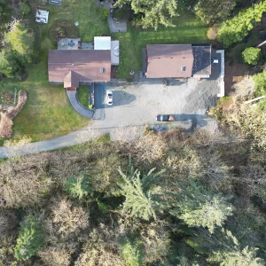
The Role of Drone Technology in Modern Land Surveying
Land surveying has come a long way, thanks to advancements in technology. One such innovation that’s revolutionizing the industry is the use of drones. These unmanned aerial vehicles are equipped with high-resolution cameras and GPS technology, making them invaluable tools for land surveyors. Whether you’re in the Comox Valley, North Island, or other areas of…

Unlocking the Potential of Specialized Logging Surveys
The lush forests of Vancouver Island have long been a valuable resource for the region, with forestry playing a significant role in the local economy. However, sustainable and responsible logging practices are essential to maintain the health of these ecosystems. Specialized logging surveys, conducted by experienced land surveyors, are key to achieving this balance. In…